Showing posts with label Tangiers. Show all posts

Monday, January 8, 2018

Iberia Network, c.1968


Reminiscent of the mid-century route map of KLM posted earlier this month, this fascinating and somewhat confusing postcard, showing Iberia's entire route system, is dated to 1968 but seems a relic of even earlier years, given its semi-medieval, hand-painted style, especially the Gothic lettering of "Mare Oceanum" set vertically on the spine of the Atlantic Ridge. It is featured for sale at this website.

The anachronism is further enhanced by the curious and highly confusing use of older names for the destinations: Nouadhibou is still shown as Port-Etienne, Dakhla in Western Sahara is referenced as Villa Cisneros, and Malabo, capital of Spain's only sub-Saharan colony, is listed as Santa Isabel, which connected to the metropole of Madrid and the large station at Las Palmas, in the Canary Islands, and which has local links to mainland Bata and to Douala, in Cameroon, which is spelled with a "V" as if carved in marble. 

The mysterious is "La Guera" which today can be found almost nowhere on any maps or airline schedules. Friends at Airline Memorabilia note that this was once an outpost in Spanish Sahara, now a ghost town. It is interesting to juxtapose this item with an Iberia route-map advertised twenty years later

The barbell-style route system is focused, naturally, on Madrid, with feeder routes to the capitals of Western Europe,  and which appears to have non-stops to Rio de Janeiro; the hub at Tenerife likewise has a non-stop to South America, reaching landfall at Montevideo; the network then extends across the southern cone to Sao Paulo, Buenos Aires, Santiago and upward to Lima, then Bogotá, then Caracas, where the route turns back to the Iberian peninsula or up to the Caribbean basin at San Juan.


Saturday, January 6, 2018

KLM Route Network, 1982.


Zooming ahead several decades from yesterday's post, a circuit-board cartography shows the six-continent, circumnavigational system of KLM. Reminiscent of the powerful, dynamic abstractions of Lufthansa's famous spinnernetz Streckenatlas of the same era, the Royal Dutch route network is simplified into web of trunk routes, yielding only general information of the intercontinental connectivity performed by the carrier. Likewise, the continents are represented with mind-bending liberties; Alaska and South America in particular bearing only slight resemblance to their true shapes. The top portion of the literature shows four of KLM's ultramodern jetliners, especially the flagship B747-200Bs, DC-8s and DC-10s. 

It is always remarkable to look back at the route maps of European flag carriers in this era, when more African capitals were served than American cities. Like many of those state airlines of the early jet age, KLM linked Europe to South America via the western edge of Africa, with Casablanca, Tangiers, and Freetown linked together in a right angle which continues on to Monrovia, Accra, Lomé and Lagos, making a northward left at Kano. A single line shoots off of Morocco for Rio de Janeiro, São Paulo, Montevideo, Buenos Aires, ending at Santiago (nearly identical to Iberia's route shown in the previous post). Today, KLM still serves all of these Mercosur cities, except for Montevideo. 

An eastern route crosses the Mediterranean to Cairo, onward to Khartoum, with an elbow passing through NairobiKilimanjaroDar Es Salaam to end at Johannesburg. To this day KLM still flies to these three east African cities; indeed, KLM is the only European airline to fly to Kilimanjaro, but sadly and surprisingly, Cairo has been terminated, as was Khartoum. 


Saturday, June 21, 2014

Royal Air Maroc: Domestic Destinations, 2011


Like its African network map, Royal Air Maroc doesn't designate the routes in its domestic network, although it operates significant bases at other major cities such as Rabat, Marrakesh, Tangier, Fez, and Agadir to both domestic and international destinations.

What's more notable is what the airline considers to be domestic: here, the realm of the kingdom clearly extends deep down the Saharan Atlantic coast well into territory claimed by the Sahrawi Republic. Tan-Tan is the southernmost RAM destination in Morocco itself; Laâyoune (styled by Timetablist by the more common El Aaiún) and Dakhla, the ancient Spanish whaling port of Villa Cisneros, are claimed by the breakaway movement.

Monday, February 27, 2012

Brussels Airport Departure Board #1

As it approaches 11:30am in Brussels, several long-haul flights are closing their doors: United to Chicago (its flight to Washington is ten minutes after noon), and Brussels Airlines SN263 to Ouagadougou and Cotonou.

There are two delayed flights to London at the top of the board, and a Finnair flight to Helsinki is on final call.

There are several Mediterranean destinations up until mid-day: Turkish to Istanbul, Tunisair to Tunis, Alitalia to Rome; just thereafter is an Iberia connection to Madrid, an El Al departure to Tel Aviv and a Royal Air Maroc flight AT683 to Tangier.

Sunday, October 2, 2011

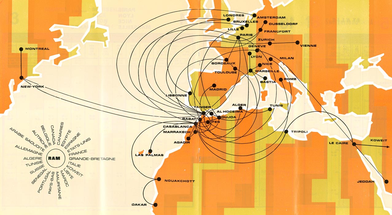
Royal Air Maroc: Systemwide Route Map, April 1976


An astonishing vintage route map, a gem of the tremendous collection of the website Timetable Images. Its issue date of April 1976 could be guessed at from the styling alone: a shag-carpet, VW-bus interior striping of the continents that follows neither national boundaries nor time zones, but zigzags to its own groovy pattern. The coastlines of the landmass are geometrically simplified, squared-off while still showing smaller juts such as Crimea and Crete, Cornwall and Cape Cod.

This quadrangularity contrasts to the jet-black route lines. Frictionless, looping ribbons convex proudly from their true navigational path, making for easy reading on the map. Northern European Routes are pulled far out into the Atlantic; Southern European lines ply semicircles over the Sahara. Tripoli and Le Caire are linked by a fanciful arc which touches mainland Greece; Nouakchott, due north of Dakar, is connected to the Senegalese capital by a wide "C" shape.

The labels are in quintessential Microgramma typeface, both on the map and at what stands in for a legend: the spiraling emblem at the bottom left, featuring the Francophone names of the nations which Royal Air Maroc serves. Such a badge seems to be an award to mark this fantastic réseau as a classic achievement of route map graphics.

All this can be admired before even considering the routes themselves, of which there are several treasures: Lille is the sixth metropolitain city served; JFK is reached from both Casablanca and Tangier, before swooping north to terminate at Mirabel; the airline stretches as far east as Koweit.

As can be seen from previous posts, RAM has expanded rapidly across Africa in recent years, but it seems to have yet matched the graphic achievements of amazing cartograph.

Tuesday, March 15, 2011

Air France: The African Routes, 1977.


In the wake of Air Afrique Week, it might be most fitting to spend the latter half of the month examining a bit more of those carriers who served West Africa during Air Afrique's existence and in the aftermath of its sad demise.

The first such example is one of the newest additions to the Timetablist collection, an Air France route map from 1977, when Air Afrique was in its prime, and Air France was just beginning to adopt its modern color scheme. Surprisingly, Air France completely defers to the West African carrier in the Gulf of Guinea region, only touching Dakar on the route to Rio de Janeiro. While the former dominions of Morocco, Algeria and Tunisia in North Africa are thoroughly serviced, France's colonial heartland is left untouched.

The service table at the bottom details Air France's weekly frequencies to North and East Africa and the Indian Ocean islands, and helpfully charts the use of particular aircraft, even if its not entirely clear which Paris airport hosts which flight. The footnotes confirm that Air France relies on Air Afrique, Cameroon Airlines, and UTA for services from Paris to West and Central Africa, and that these airlines, along with Air Djibouti, Air Comores, and Air Madagascar operate intra-African and domestic networks.

The next post details the Eastern portion of the map.

Sunday, January 24, 2010

Iberia: Eastern Hemisphere, February 2006


Iberia's eastward system looks slimmer than its 1988 operations, but still connects to Dakar, Lagos, Malabo and Johannesburg in sub-Saharan Africa. Aside from the dense array of Moroccan cities, including the Western Saharan capital of El Aaiun, Iberia is otherwise surprisingly spare on North African destinations: no Algerian or Tunisian cities, for instance.