Showing posts with label Apia. Show all posts

Tuesday, October 2, 2012

Air Pacific Network, 2004


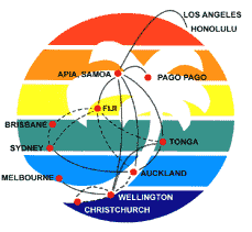
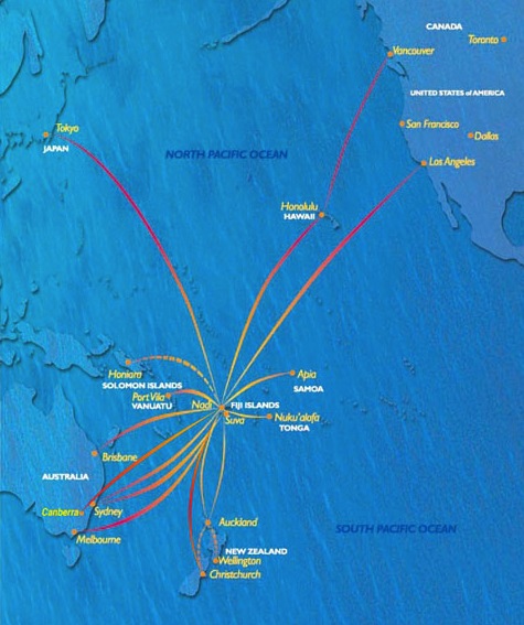
Another colorful map from a South Pacific carrier, this Air Pacific, the state airline of Fiji, displays a fan of spectral ribbons across the vast ocean, from Vancouver and Tokyo to Canberra and Christchurch, all via Nadi, the international airport Vita Levu. Tokyo, Vancouver, Wellington and Canberra have all been cancelled: this map was during a very brief period when Air Pacific flew to the Australian capital, which currently enjoys no international services.

Friday, September 28, 2012

Polynesian Airlines Network, c.2001


A rainbow-colored route map for Polynesian Airlines from about ten years ago, via the wonderfully strange, half-dormant website, World of Islands. Its not explicitly clear what the dotted lines refer to, but perhaps Air Pacific or other carriers operated these intra-Antipode routes on Polynesian's behalf.

At the time, Polynesian, founded in 1959 and one of the dominant South Pacific carriers, ran a very prestigious Apia-Honolulu-Los Angeles service, which reportedly bankrupted the company. Sadly, today the airline is relegated to domestic service as Virgin Samoa (formerly Polynesian Blue) runs long-haul flights to Australia and New Zealand. The only service northwards is to Honolulu on Air Pacific, the Fijian carrier.

Monday, September 24, 2012

Hawaiian Airlines Routes, 1990


Just three years after the last post, this next, much more muted feature from fabulous Departed Flights shows Hawaiian Airlines having dropped Anchorage and Portland, but otherwise expanded dramatically across the Pacific, reaching Australia and New Zealand while also adding a Polynesian fan of Tahiti and the Cook Islands, along with Guam in Micronesia. Sadly today, most of these exotic island destinations are gone, with the airline only resuming Sydney service and only next year returning to Auckland, and still serving Pago Pago and Papeete

Sunday, September 23, 2012

Hawaiian Airlines Route Map, 1987


Yet another delight from Departed Flights, this wonderfully-vintage Hawaiian Airlines route map from 1987, showing the small airline bridging the Pacific from Anchorage to Apia, and interesting mix of ferrying West Coast vacationers to the islands, interlinking the archipelago state, and linking the tiny isles of Polynesia with Honolulu, the central Pacific metropolis. Note that most of the Hawaiian destinations are labeled by the islands, not the airports.